


Total Ascent: 2100ft
Highest Point: 4400ft
Total Distance: 8.8 miles
Location: N 47° 2.2560, W 121° 32.8800
Required Permit: Northwest Forest Pass
Difficulty: Moderate
 We’ve spent a lot of time in the Highway 410 Corridor in the last few months, exploring both popular and less-travelled trails. This week was no exception. Following the promise of big views of the White River Valley, we decided to take on the Palisades Trail #1198, which climbs up into the rocky cliffs above Snoquera Falls.
 The cliffs surrounding Snoquera Falls and rising above Camp Sheppard were likely named “palisades” for their resemblance to castle walls. There are a number of places in Washington dubbed “palisades” for this reason. You can read more about this history of this area in our post on Snoquera Falls.
 The trail begins right from the highway, and wastes little time drawing you up and away from the noise. Almost immediately you will arrive at a junction with the White River Trail #1199. Keep left, following the Palisades Trail as it begins to tackle the mountainside in earnest. Following Dalles Creek, the route soon beings switchbacking up the narrow canyon through lush forest. As you climb, watch the underbrush of salal and salmonberry slowly give way to a moss-covered forest floor. A great deal of trail work has smoothed out the scree that used to be a larger problem in the first mile of trail.
Your first destination is Lower Dalles Falls, a crashing wall of water tumbling down a wall of rock. Trees obscure the top of the falls, but a short side trail allows for a closer look. Even up close you cannot get a full view of the 280ft falls, but that doesn’t stop the falls from being pretty impressive anyway. Keep in mind that this is a snow-driven creek, and in the high summer it is not much more than a glorified trickle. If you want a big show, late spring and early summer are the best time to visit. The area around the falls is also home to another often mentioned highlight of this hike - Calypso orchids, which can be found along the trail leading up to the falls during the spring months. The small, delicate flowers can be a little hard to spot if you’re not looking for them.
 Push past the falls, up the wooden staircase and continue to switchback up toward some more level ground. Cross Dalles Creek and enjoy this section of level trail. Before long, at about the 2.5 mile mark, you’ll reach the first viewpoint along the trail. This is the lowest and least expansive view of the surrounding landscape, but also makes for a decent stopping point for those looking for a shorter day. Sun Top Mountain is almost directly across from you and depending on the time of year, you can pick out Skookum Falls across the valley.
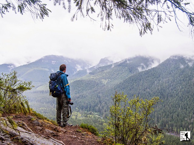
If you decide to push on, you will soon be traveling through old growth, gradually climbing another mile to the next viewpoint. From here the views are impressive. Mt. Rainier and Sun Top Mountain rise above the valley. Looking southeast you can see your final destination; a rocky outcropping further down the ridge, offering commanding views of the landscape.
Press onward, following the trail as it veers away from the cliffs and briefly passes through a section of young forest still recovering from a recent harvest before dipping down and crossing Snoquera Creek. Once across, the final lookout is within reach, and before long you’re looking for a comfortable place to settle in and soak up the view. For those looking for an even longer day, you can press on to the Ranger Creek Trail #1197 for access to Little Ranger Peak and perhaps the Ranger Creek Shelter beyond. You can also push past the shelter to connect with the Noble Knob Trail #1184. From that junction it’s a quick jaunt past Twentyeight Mile Lake and up to the top.
 This is an excellent trail especially in the late spring when the wildflowers are popping up and Lower Dalles Falls is really flowing. The variety of stopping points along the way also makes dealing with lingering snow a little easier. If late snow is too much after the first viewpoint, you’ve at least gotten a taste of the hike. This is fairly popular hike, and because it connects with a number of other trails, it is also one often used by mountain bikers. The trail is a little steep for some, but reaching the first viewpoint should be attainable for most hikers. With summer not yet in full swing, we recommend you try this steady climb through old growth to big views of Mt. Rainier soon.
To get there, take I-5 south to Highway 18 Exit 142A. Follow Highway 18 into Auburn and take the SR 164 exit. Head left on SR 164 through Enumclaw to SR 410. Head left onto SR 410 for 26.8 miles to a dirt pullout on the left side of the highway, a quarter-mile past the Skookum Falls viewpoint. The trail begins here at a small signed trailhead. -Nathan
Print Google Directions >>
0 Comments:
Post a Comment