


Total Ascent: 2100ft
Highest Point: 4750ft
Total Distance: 8.5 miles
Location: N 47° 25.9197, W 121° 22.8277
Required Permit: None
Difficulty: Easy
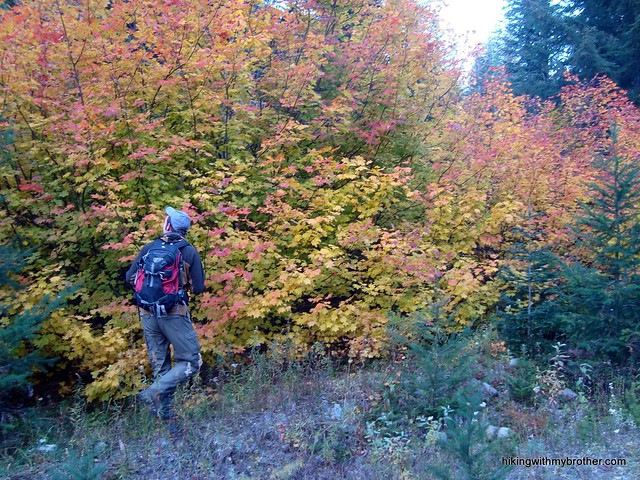
 This week found us just over Snoqualmie Pass exploring some of the shorter jaunts around Hyak. After a few weeks of longer forays to various summits along the I-90 corridor, we were looking forward to a leisurely hike. A mountain lake seemed the ideal destination on a brisk October day, so we pointed the car in the direction of Kendall Peak Lakes and hit the road.
Kendall Peak Lakes have always been lakes that were seen more than they were visited. Couched in a cul-de-sac of mountain ridges,
 the three lakes were so often observed from the surrounding lofty heights that we today we continue to refer to them as just that: lakes seen and accessed via Kendall Peak. Nowadays, extensive logging and the roads that go along with it have hewn a much easier route to Kendall Peak Lakes, though it was a high price to pay for ease of access, as the vast fields of clear-cut forest are still struggling to recover.
The trail is mostly decommissioned logging road, making for a leisurely stroll through alders and vine maples. The shrubbery quickly gives way to long views of stump-strewn clear cuts complete with young saplings struggling against low underbrush. The carefully carved slopes of the Snoqualmie Ski Resort contrast with the clear-cuts and dominate the view. The road is short - just a few switchbacks and one slightly confusing
 intersection are between you and a clear path toward the craggy mountaintops of the Alpine Lakes Wilderness.
As the logging road begins to thin and taper out, keep watch for a cairn indicating a boot-path to the lakes. The roughly cut trail will bring you to the first meadow-bound lake. More accurately a pond, the reed-lined waters are surrounded by marsh, so watch your step. Upon reaching the lake, the trail becomes more intermittent, branching off in dozens of directions. There is more than one viable route up to the next lake, accessed on either side of the pond.
The middle child of the Kendall Peak Lakes makes for something more of a destination, but it pales in comparison to the last lake. We highly recommend that you press onward and upward. The trick is to find the trail to access it. Simply work your way around to the far side of the second lake to the talus field and start climbing your way up.
 Hopefully you’ll be able to find the shadows of a path up the very steep mountainside. Ascend roughly 200’ to the last and largest of the Kendall Peak Lakes. Surrounded by steep cliffs and talus, the lake somehow feels remote and private. Unpack your lunch and enjoy.
This is great hike for those looking for a quick escape – a taste of the wilderness just a few miles away from I-90. In the winter this is an extremely popular snowshoe route, since the grade and distance are perfect for a romp through fresh powder. Keep this one on the list for the first snowshoe trip this year.
To get there, take I-90 to the Hyak Exit #54 and head right to the Gold Creek parking area. Depending on snow conditions, you can either park here or continue the half-mile on Forest Road #9090 to the road block before piling out and heading up. - Nathan
Print Google Directions >>
10 Comments:
Fantastic! I've always wanted to go there. Did you see any fish in any of the lakes?
The first two lakes looked pretty empty of fish. They're pretty small. The last lake is large enough that it could support some fish - though we didn't see any.
Do you recommend this hike during December?
Absolutely! This is a pretty popular winter destination for snowshoeing, and there is plenty of snow in the pass already! Forest road 9090 will be covered in snow, so you'll end up slushing an extra 1/2 mile each way. Eighty percent of the trail is road which will be easy to follow in the snow. The final stretch to the first lake might be difficult to navigate without a GPS, or map, but I think it's likely that other snowshoers have already cut a route which you can follow. Have fun, and let us know how the trip goes!
I've only been up there in winter, but this would be perfect for a summer afternoon! Do you know if you're allowed to bike up the road? The forest service site only mentions that motorized vehicles are illegal.
Thanks for the inspiration, brothers. :^)
Bikes are totally fine - no worries there. It's a fun little hike, one that is probably better when the lakes are filled with snow melt. If you go too late in the summer, the lakes will be lower and less impressive.
Have fun!
Just did this trail last Wednesday (5/4/11) in snow shoes - what a fantastic outing! I was actually looking for something rather easy, since my buddy was visiting and has only been in snow on one other occasion. There is still snow at the parking lot, so this trail is still ripe for snow shoeing.
We actually didn't make it up to the lakes on account of getting out there a little late, but it was fun anyhow - maybe next time.
Thanks Nathan for posting this one. It was exactly what we were looking for!
Jonathan
Glad it worked out for you Jonathan! Wednesday was a great day to be out in the snow, bet there was some great vistas to take in. We're glad it all worked out! Definitely head back in the summer to check out the upper lake.
Feel free to post any pics up on the Facebook page!
I am trying to download the GPS track from
http://www.trimbleoutdoors.com/ViewTrip.aspx?tripId=540068&utm_source=embedmap
but when I click on download gpx it says " With our Trip Planner tool, you can download the GPS files (.gpx) for this trip for use with popular navigation devices like Garmin, Magellan, and DeLorme."
Is there a way to download or receive the GPS track for this trip without acquiring software from TrimbleOutdoors?
Can you please email me the GPS track or provide it in a location without cost.
I post my trips on everytrail.com.
Some people use connect.garmin.com
Thank you for posting your trips.
Hi Dan, no problem! Some changes recently happened that make it no longer free to download our GPX files. We are in the process of making the files downloadable again from our site. There is now a link above the map called "Download GPX File", which should work! Thanks for following and enjoy the hike!
Post a Comment