


Total Ascent: 2400ft (1500ft in; 900ft out)
Highest Point: 5100ft
Total Distance: 10.4 miles
Location: N 47° 43.103, W 121° 3.27
Required Permit: None
Difficulty: Moderate
 With autumn in full swing we wanted to find a hike with plenty of fall foliage and a taste of the wilderness. We settled on Lake Josephine in the Stevens Pass area, which was a little light on the wilderness, but made up for it with brilliant fall colors, pristine alpine lakes, and spectacular weather.
 Back around the turn of the 20th century, Albert Hale Sylvester was a forest supervisor in the Snoqualmie Ranger District and would later go on to supervise the Wenatchee Ranger District. During his career he explored, mapped and named thousands of features, including Lake Josephine, named after Josephine Williams, the wife of one of the rangers in his district. Often referred to as A.H. Sylvester, he began the tradition of naming lakes after women, a legacy that is now splashed across maps of the Cascades.
 The hike begins from the Stevens Pass Ski Area parking lot, picking up the Pacific Crest Trail #2000 (PCT) as it climbs its way through the ski slopes. The well-trodden trail winds its way up through brushy ski slopes, offering glimpses of the surrounding landscape as it meanders under the occasional ski lift. After two miles of traversing the slopes you’ll crest the first rocky ridge to find Mill Valley spread out before you as well as the Jupiter Express ski lift. From this vantage point you can see Mount Stuart and the rest of the Stuart Range looming large to the southwest. Note the large forested bowl almost directly across Mill Valley from you. Nestled within that bowl is Susan Jane Lake and just over that ridge is Lake Josephine, your final destination. You’ll need to traverse the entire valley to get there, so enjoy the view for a few moments before heading down the mountainside.
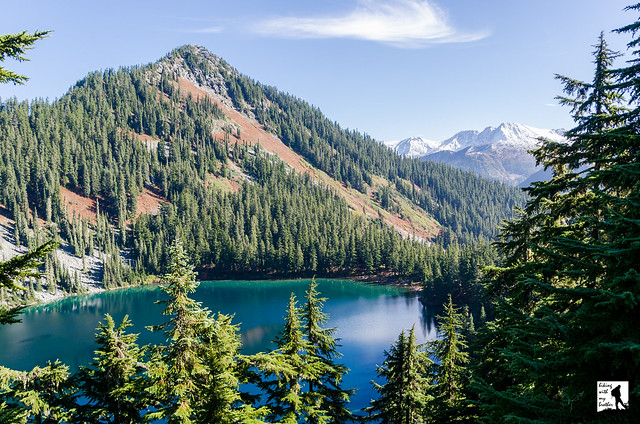
 The trail down to Mill Creek is largely exposed, affording big views of Mill Valley. Follow the trail as it gently guides you downward through talus fields and the occasional clump of evergreens. Ignore the power lines and ski lifts and push onward, eventually crossing Mill Creek and beginning your climb out of the valley. At about three miles from the trailhead, shortly after you enter a quiet forest of hemlock and fir, cross the Alpine Lakes Wilderness boundary and leave the slopes behind you. Continue the climb for another mile before reaching a small tarn and just above it Lake Susan Jane. There are several campsites here for those looking to make a longer stay and the lake makes for a decent destination if you’re short on time. To reach Lake Josephine, continue to press upward for another half mile to a forested plateau and the junction with the Icicle Ridge Trail #1551. Peer down at glimmering Lake Josephine a few hundred feet below.
 When you’re ready, head left, leaving the PCT for the Icicle Ridge Trail and continuing to climb upward, passing several tarns as you work your way around the lake high above the shore. The trail is somewhat rockier and rougher than the PCT, but easily navigable. Eventually the trail dips sharply down to the lake, depositing you at the edge of Icicle Creek near several established campsites. Take a few minutes to explore the shore and stake out a place for lunch or a snack and take in Josephine’s crystal clear waters. Follow the rushing sound of Icicle Creek for glimpses of Icicle Valley and the Stuart Range beyond. Once you find a spot, settle in and enjoy this little slice of wilderness.

To get there, take Highway 2 to the Stevens Pass Ski Area. Park on the south side of the highway. The trailhead can be found to the east in the parking lot furthest from the main ski lodge. Privy available. -Nathan
Print Google Directions >>
0 Comments:
Post a Comment