about us | links | permit info
Subscribe to Hiking With My Brother Email Subscribe Follow Hiking With My Brother on Facebook Follow Hiking With My Brother on Twitter Hiking With My Brother Picasa Hiking With My Brother YouTube

Third Beach Trail

Our Hiking Time: 2h
Total Ascent: 250ft out
Highest Point: 250ft
Total Distance: 4.0 miles
Location: N 47° 52.6683, W 124° 35.2566
Required Permit: None
Difficulty: Easy

Nathan's Photo
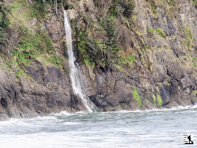
A few months ago we took a weekend to head out to the Olympic coast to explore some of the beach hikes near La Push. Somewhat remote and a little on the wild side, the three La Push beaches are separated by headlands that jut forcefully into the Pacific. One of the more popular hikes is Third Beach, named for its distance from La Push. Boasting a scattering of seastacks and a tumbling waterfall, Third Beach is a classic Olympic coast hike.

Back in 1898, prospectors began investigating areas around Third Beach for oil. An area near the north end of Third Beach was identified as a potential site and work began to install an oil well at that location. The remoteness of the beach made the project much more challenging than investors expected. At least one barge carrying equipment for the well broke up against the rocky shore, though enough equipment was salvaged to keep the project alive. By 1902 the first oil well on the Olympic coast was in operation, but drilling only managed to struggle down about 650 feet before the well collapsed and the project was abandoned. Originally the access road to the oil well, the original trail to Third Beach led through the rusting remains of the ill-fated project. The trail has since been rerouted, though it is still possible to find what remains of the engines, boilers and pipes of the La Push Oil Well in the underbrush of Third Beach.

The trail begins from the roadside trailhead, immediately diving into a mossy forest of spruce and hemlock following what remains of the oil well access road. Before long the road yields to a fern-lined trail that veers toward the ocean. After about a mile the trail begins its descent to the beach, eventually crossing Newbert Creek and delivering you to the sand at the 1.3 mile mark. Look out across the water to see the seastacks rising out of Strawberry Bay. The headland to the north is Teahwhit Head; to the south is Taylor Point; and between these two craggy bookends there is about a mile of beach to explore and enjoy. Head south toward Taylor Point to get a better look at the waterfall spilling into the sea from the cliffs above. Stake out a section of beach and watch the waves roll in.

If you’re looking for the right balance of wild Olympic Coast and easy access, it’s hard to beat Third Beach. With a trailhead just off the highway and a well-maintained trail that delivers you to the shore in just over a mile, Third Beach is easily accessible for hikers of almost any age. There are a few campsites in the area for those looking to make an overnight stay. If you’re looking to add a little more milage, Second Beach is just down the road and makes for an easy addition to a day of hiking.

To get to there, take the Bainbridge Island ferry to Bainbridge Island. From the terminal, follow SR 305 for 13 miles to SR 3 North. Follow SR 3 to the Hood Canal Bridge, taking a left over the bridge onto State Route 104. Follow SR 104 as it merges onto US 101 and continue 35 miles to Port Angeles taking a left on Lincoln Street, which becomes US 101. Continue for about 54 miles to the junction to La Push Road, also known as SR 110. Turn right and continue on SR 110 for 7.8 miles to Mora Road. Veer left and continue another 3.8 miles to the trailhead and parking area on the left side of the road. -Nathan

Print Google Directions >>

Third Beach

Green Lake and Ranger Falls

Our Hiking Time: 4h 15m
Total Ascent: 1400ft
Highest Point: 3200ft
Total Distance: 9.6 miles
Location: N 46° 58.6566, W 121° 51.4683
Required Permit: National Park Pass
Difficulty: Moderate

Nathan's Photo
A few weeks ago we headed back to the Carbon River Entrance of Mt. Rainier National Park to do a little more exploring. This time we headed down the washed-out Carbon River Road to the Green Lake Trail, one of the more popular and family-friendly hikes in the area that includes an alpine lake, old growth forest, and an impressive set of waterfalls.

Green Lake is named, somewhat unsurprisingly, for the color of its emerald waters set against the evergreen forest that crowds its shores. The lake is drained by Ranger Creek, christened by The Mountaineers in 1911 to honor the hard-working rangers of Mt. Rainier National Park. However, access to Green Lake and Ranger Creek was difficult when the park was established in 1899. What we now know as the Carbon River Road began as a wagon road built by the Washington Mining and Milling Company in 1907. When most of the large scale mining operations had left the area by 1913, park administrators saw an opportunity to develop an area of park that was closer to Seattle and Tacoma. Pierce County agreed to modernize and pave the road from Wilkeson to the park boundary, while park administrators built the road from the boundary out to Carbon Glacier. The Carbon River Road became the park’s second road when completed in 1921, though it took until 1925 for the county to complete their portion of the project. That same year the road suffered the first of many floods that would washout the road and require extensive repairs. Reopened in 1926, a 1934 flood washed out and permanently closed the road beyond Ipsut Creek. Floods followed in 1955, 1959, 1977, 2006 and 2008. The road has remained closed at the Carbon River Entrance since the 2008 flood and there are no immediate plans to repair it.

The hike begins from the Carbon River Entrance, following the Carbon River Road through a temperate rain forest of fir and cedar. Many people opt to bike the three miles to the Green Lake Trailhead, though there is something to be said for the more leisurely walk through the woods. Once you reach the trailhead, head up the well-maintained trail and into stands of moss-covered old growth. Your climb is helped along by wooden steps and stone stairs built into the trail by countless volunteers over the years. After a mile of moderate switchbacks, find the signed spur to Ranger Falls leading out to an observation area. Watch as Ranger Creek tumbles more than 150 feet over the three-tiered falls. The water flows year-round, but the falls are at their best in late spring and early summer when melting snow swells the creek.

After you’re done with the falls, return to the main trail and continue the last .8 miles to the lake. As you near the lake, the trail flattens out and crosses a log bridge over Ranger Creek and quickly delivers you to the shores of Green Lake. While the official trail ends here, paths can be found leading around the lakeshore. Do some exploring to find a spot to settle in and enjoy the view. The lake is flanked by Gove Peak to the east and Arthur Peak to the west. To the south is Howard Peak and the taller Tolmie Peak, which boasts a lookout cabin that can be seen on good days. Looking for more? It is not uncommon for peakbaggers to bushwhack their way up to the top of Gove or Arthur Peak, following the faint trails of those that went before them. Use caution if you attempt these scrambles.

This hike has a little bit of everything - a picturesque alpine lake, rushing waterfalls, and lush evergreen forests - which may explain why it is so popular. And while there is some elevation gain, the climb is not so strenuous that it will pose much of an obstacle for most families. Easily accessible and approachable for most hikers, this is a great hike to add to your list this year.

To get there, take I-5 South to I-405. From I-405 take SR 167 south toward Auburn. In 20 miles take the SR 410 Exit toward Sumner/Yakima. Follow SR 410 for 12 miles to SR 165. Take a right and continue on SR 165 for about 10 miles through Wilkeson and Carbonado to the Carbon River Road/Mowich Lake Road junction. Veer left onto the Carbon River Road and follow for 7.7 miles to the Carbon River Entrance of Mt. Rainer and parking. -Nathan

Print Google Directions >>

Green Lake

Rialto Beach to Hole-in-the-wall

Our Hiking Time: 1h 45m
Total Ascent: 0ft
Highest Point: 0ft
Total Distance: 3.4 miles
Location: N 47° 56.5016, W 124° 39.0783
Required Permit: None
Difficulty: Easy

Nathan's Photo
Not long ago, we took a long weekend and headed back out to the Olympic coast to continue exploring some of the wildest and more pristine beaches in the state. While some beaches required quite a trek to reach, others were easily accessed from a parking area. One of the most accessible was Rialto Beach, a rocky, log-covered stretch of shore featuring an ocean carved headland passage known as Hole-in-the-Wall.

Situated on land historically claimed by the Quileute Tribe, Rialto Beach was the location of the first encounter between the tribe and European explorers. In 1808, a Russian fur trader foundered on the beach, and the crew was attacked by Quileute tribesmen. While Russian firearms repelled the initial attack, a number of the crew were captured and held as slaves for roughly 18 months before the survivors were released to a Russian cargo ship. As the decades passed, Europeans continued to move into the area, and by 1881 the Quileute Reservation was created, which included Rialto Beach. However, storms in 1910 shifted the course of the Quillayute River, and with it the boundaries of the reservation. This marked the beginnings of a dispute between the tribe and Olympic National Park that threatened to affect the public's access to Rialto Beach. The dispute continued for decades, and it was not until 2012 that Congress passed legislation to settle the matter, assuring continued access to the beach.

Sometime after the turn of the last century, the beach was dubbed “Rialto” by a local celebrity, Claude Alexander Conlin, a magician and illusionist who rivaled Houdini in popularity. Known professionally as The Great Alexander, he used his fortune to buy land near the present day Mora Campground and built a large home that stood until it burned down in 1928. “Rialto” was a popular name for theaters at the time, and continues to be associated with theater and the performing arts.

The hike begins from the Rialto Beach parking area, following a sandy path through a stand of windswept trees. After clambering over the piles of driftwood that have collected at the edge of the beach, you'll emerge onto the pebbled shore. Head right, skirting the edge of the Pacific as your boots crunch and sink into the beach. Keep an eye out for wildlife - it is common to see a variety of birds and sea life.  After about .9 of a mile reach Ellen Creek, a fairly wide and swift stream flowing into the ocean. Depending on the tide and the conditions, you may be able to find a log crossing. If not, you may get a little wet scampering across. Note that dogs are not allowed beyond Ellen Creek.

Once you’ve forded the stream, continue another .8 mile to Hole-in-the-Wall. Only accessible at low tide, this arch provides access through the headland to the beaches beyond. Take some time to explore the tidepools here, as they are brimming with marine life, including seastars, anemones, and crabs. Once you’ve had your fill of Hole-in-the-Wall, head back toward the parking area and marvel at how much the shifting tide has changed the beach.

If you’ve never made it out to one of the many beaches on the Olympic Coast, Rialto Beach makes a great first impression. Short on distance and easily accessible, this hike allows any hiker to experience the rugged headlands and rocky shores common along this section of the coast. For those looking for something a bit more wild and less crowded, nearby Second Beach and Third Beach are excellent options.

To get to there, take the Bainbridge Island ferry to Bainbridge Island. From the terminal, follow SR 305 for 13 miles to SR 3 North. Follow SR 3 to the Hood Canal Bridge, taking a left over the bridge onto State Route 104. Follow SR 104 as it merges onto US 101 and continue 35 miles to Port Angeles taking a left on Lincoln Street, which becomes US 101. Continue for about 54 miles to the junction to La Push Road, also known as SR 110. Turn right and continue on SR 110 for 7.8 miles to Mora Road. Veer right and continue another 5 miles to the road end and the parking area. -Nathan

Print Google Directions >>

Rialto Beach
Copyright 2008-2016 - hikingwithmybrother.com
hikingwithmybrother@gmail.com