


Total Ascent: 250ft
Highest Point: 200ft
Total Distance: 4.0 miles
Location: N 47° 53.460, W 124° 37.638
Required Permit: None
Difficulty: Easy
 Earlier this year we spent a weekend wandering down the beaches near La Push. There are three distinct beaches, each hemmed in by rocky headlands. Little effort went into naming these isolated beaches, now known simply as First, Second and Third Beach, perhaps because these stunning seascapes need no further decoration. Of the three, Second Beach is often cited as the favorite, and after our hike down this wild section of the Olympic coast, we can see why.
 The hike begins from the roadside trailhead, dipping past the Lonesome Creek Fish Hatchery and quickly crossing over the log bridge that spans the creek. The graveled trail is wide and well-maintained, a testament both to the tireless efforts of volunteers as well as the thousands of boots that trek down the trail every year. The fern-lined trail rises gently as it cuts through a mossy forest of spruce and hemlock. As the trail levels out and enters the Olympic National Park, the trees thin, giving you the first glimpses of the ocean below. From here the trail quickly works its way down the bluff, steeply descending down to the log-strewn beach.
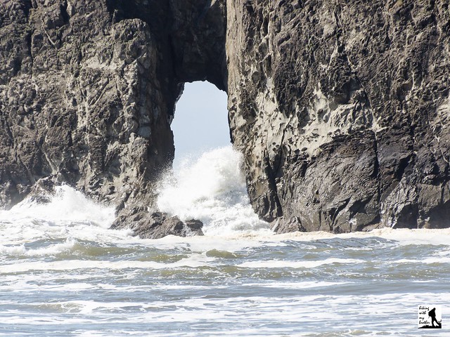
 Once you arrive take a few moments to find a quiet place take in the landscape. To the right, find the headland known as Quateata and the natural arch the waves have carved into the rock. Ahead is Crying Lady Rock, the largest of the seastacks in this area, collectively referred to as the Quillayute Needles. To the left, a little over a mile down the beach is Teahwhit Head, the other end of the beach. If it is low tide, there is a lot to explore, as the rocky shore will be riddled with tidepools. After you’ve had your fill of starfish and anemones, make the journey down to Teahwhit Head to find more rocky seastacks and another arch.
No trip to La Push is complete without taking the time to explore Second Beach. While the steep drop to the beach might be challenging for very young hikers, most folks should not have much difficulty navigating this short trail. A popular overnight destination in the summer, expect to see folks tucked into the forest just above the beach. And if you time your visit in the early spring or early fall, you may be lucky enough to catch the telltale spray of migrating whales on the horizon.
 To get to there, take the Bainbridge Island ferry to Bainbridge Island. From the terminal, follow SR 305 for 13 miles to SR 3 North. Follow SR 3 to the Hood Canal Bridge, taking a left over the bridge onto State Route 104. Follow SR 104 as it merges onto US 101 and continue 35 miles to Port Angeles taking a left on Lincoln Street, which becomes US 101. Continue for about 54 miles to the junction to La Push Road, also known as SR 110. Turn right and continue on SR 110 for 7.8 miles to Mora Road. Veer left and continue another 2.3 miles to the trailhead and parking area on the left side of the road. -Nathan
Print Google Directions >>
0 Comments:
Post a Comment