


Total Ascent: 1300ft
Highest Point: 5800ft
Total Distance: 6.1 miles
Location: N 47° 2.3333 W 121° 50.1539
Required Permit: Northwest Forest Pass
Difficulty: Moderate
 At the end of last summer we headed out toward the Carbon River entrance to Mt. Rainier National Park to do a little exploring in that area. One of the hikes we chose was Summit Lake, which is also one of the most popular. With big views of Mt. Rainier and a sizable alpine lake, it was easy to see why.
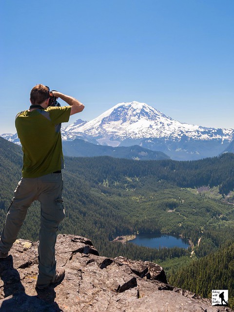
Summit Lake is a glacially carved alpine lake situated at the upper end of the Cayada Creek Valley just inside the Clearwater Wilderness. The Wilderness was established in 1984 and now protects over 14,000 acres of old growth forest and wildlife. Records are a bit sketchy, but it seems likely that the Summit Lake Trail was first blazed by the Forest Service when building the fire lookout that was once perched on nearby Bearhead Mountain. Summit Lake serves as a excellent water source in the summer months, and the lookouts stationed on Bearhead Mountain would have been drawn to the picturesque setting of the lakeshore. Today, visitors flock to the Summit Lake to take in that same alluring mixture of meadow, snowcapped mountain and alpine lake.
 From the trailhead, the Summit Lake Trail #1177 begins by climbing up through a young forest still recovering from a recent harvest. Soon find yourself entering more mature stands of fir and hemlock as the trail swings into a long switchback up the mountainside. The trail here is fairly wide and well maintained, though there are plenty of roots to trip you up if you’re not paying attention. After about a mile of trail reach a junction with the Carbon River Trail #1179 and Twin Lake. A short unmarked trail leads out to lonely Twin Lake, which lacks both a twin and the impressive landscape waiting at Summit Lake.
Push on from the junction to one of the steeper sections of the hike, following the trial as it quickly ascends the ridgeline. The grade soon becomes more reasonable, giving you time to enjoy the wildflowers that often line the trail, as well as occasional pocket views of Lake Lily hiding on the other side of the ridge. Roughly 2.5 miles from the trailhead emerge from the woods into the grassy meadows surrounding Summit Lake. Ahead of you the rocky prominence of Summit Lake Peak rises directly behind the lake and as you reach the lakeshore, Mt. Rainier looms large to the south. Settle in to enjoy the lake or press onward for bigger views.
 If you’re up for more, the trail splits into a loop, winding around the lake and up to the top of Summit Lake Peak. Either way you go, there is often wildlife found in the meadows, including bear, deer, marmot and elk. The trail to the top is more challenging than the trail to the lake; it’s rough, steep and narrow, but the rewards are worth the extra effort. From the top, the deep blue of Summit Lake competes with the white flanks of Mt. Rainier. The closest neighbors are Bearhead Mountain to the west and Pitcher Mountain to the east, with Coplay Lake filling a bowl just to the right of Bearhead. Beyond that, an ocean of mountaintops spreads out in every direction, with far too many peaks to name. When you’ve had your fill, continue down the trail and complete the loop.
This is a fairly popular trail in the summer months, and it's easy to see why. The wildflower-filled meadows around Summit Lake are sure to please any fan of an alpine lake, and the big views from the top of Summit Lake Peak are more than enough to satisfy a devoted peakbagger. While it does have some elevation, most hikers will find this trail fairly accessible. And, with campsites available around the lake and more to explore along the Carbon River Trail #1179 and the Bearhead Mountain Trail #1179.1, this hike also makes for a decent backpacking destination.

Print Google Directions >>
4 Comments:
Love the site but you guys should think about putting a timestamp on your blog posts
kinda wish I knew when this report was from
Great post guys! Easily one of my favorite hikes, the drive up can be a little trying but the destination is well worth it.
Nathan - we don't use the time stamp because folks think the date we post a hike is the date we did the hike. That is often not the case. The easiest way to figure that would would be look at our photo albums on Picasa which are organized by the date of the hike. https://picasaweb.google.com/110833407657914921392?noredirect=1.
Tim and Marilee - agreed, it's well worth the effort. While the driving from the Carbon River can be a little tough, the road is usually in decent shape. It's just long and sometimes a little too narrow!
Post a Comment