


Total Ascent: 4000ft
Highest Point: 6400ft
Total Distance: 10 miles
Location: N 47° 27.0540, W 121° 5.0940
Required Permit: Northwest Forest Pass
Difficulty: Hard
 With summer now in full swing, we have been packing as many summits into our weekends as possible. In the last few weeks we’ve been out to the Olympic Peninsula and down Highway 410 and even had a chance to drive over Snoqualmie Pass and explore the Salmon la Sac area. We went to Salmon la Sac looking for a quiet trail with some big views, and settled on Davis Peak, one of the many mountaintops in the area and the one-time site of a fire lookout. Though a little on the challenging side, Davis Peak delivered exactly what we were looking for.
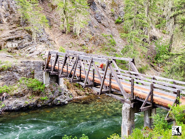
The Davis Peak Trail #1324 begins with a short jaunt across a sturdy bridge spanning the Cle Elum River before beginning its long, steady ascent up the mountain. Well-maintained and relatively free of rocks and roots, the trail climbs through a variety of landscapes; everything from sections of old growth, meadows, recovering burn zones and open ridgelines offering sneak peeks at the views to come. As engaging as the trail is, it is almost overwhelmed by the trail’s defining characteristic: its seemingly endless series of tight switchbacks. Depending on how you count a switchback, the Davis Peak Trail racks up at least 90 as it ricochets up toward the summit.
 Gaps in the treeline continue to widen as you climb, with the occasional talus field framing views of nearby lakes and mountaintops. Around the two mile mark you’ll reach the edge of the burn zone and the last of the tree cover. Continue onward and upward through rocky terrain to the first ridgeline. From here a false summit and lingering snow work together to lure hikers off the main trail. Keep an eye on the trail. If it suddenly turns into a rocky scramble, you’ve gone too far. Backtrack to rejoin the main trail as it drops to the northwest, off the ridge and down into a bowl. The route traverses across the bowl and the snow-fed creek before switchbacking up to the next ridgeline.
Once you gain the ridge, look around for the short side trail out to the grassy meadow that is the former lookout site. After checking out what is left of the lookout’s foundation, push up the last half-mile or so to the summit. From here the views are enormous. The two lakes below are Terrance and Opal Lakes. Face north you’ll see the other nearby prominences on Goat Mountain, Mt. Daniel and Mt. Hinman. Over to the west Mt. Stuart dominates the skyline, with nearby Hawkins Mountain rising underneath. Turning to the south find Jolly Mountain, Sasse Mountain, with Cle Elum Lake and Mt. Adams in the distance. Swing west to find Red Mountain, Lemah Mountain and Chikamin Peak. Settle in and enjoy the panorama.
 This is not an easy hike. While the trail is in good shape, the steep grade, tight switchbacks and sun exposure can pose a challenge. Be prepared to log some extra trail hours working your way up to the summit and taking your time on the descent. While you can expect to put in some extra effort to reach the top, you can also expect to have the views largely to yourself. The foot traffic on Davis Peak is fairly light, and most hikers stop at the lookout site. This is a great hike for anyone looking for a challenging summit and solitude.
To get there, take I-90 to Exit 80. Head left over the freeway following Bullfrog Road to SR 903. Follow 903 16.6 miles through Roslyn and along Cle Elum Lake to FR 4330 just beyond the Salmon La Sac guard station. Veer right, avoiding the campground and continuing on FR 4330 for 1.6 miles to the Paris Creek Trailhead. If your vehicle can handle slightly rough gravel roads, head down FR 134 to the lower parking area and the trail; otherwise park at the Paris Creek Trailhead and hike the .25 miles down to the trailhead. –Nathan
Print Google Directions >>
0 Comments:
Post a Comment