


Total Ascent: 1600ft
Highest Point: 4600ft
Total Distance: 8.5 miles
Location: N 47° 51.1680, W 123° 5.7780
Required Permit: None
Difficulty: Moderate
 A few months ago we headed across the water to the Olympic Peninsula to take on a hike that promised lakes, mines, creeks, and the wreckage of a B-17. The Tubal Cain Mine Trail snakes through the Buckhorn Wilderness, tracing the route miners took back in the early 1900s to reach their mining camps.
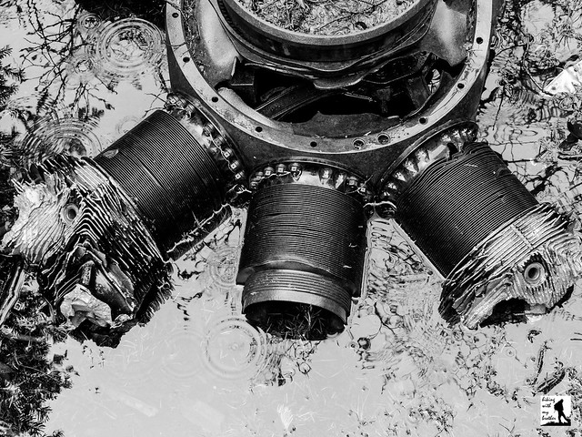
This hike has a little bit of everything, from lakes and creeks to canyons and mountain passes. With multiple destinations along the trail, you can tailor this hike depending on your time and company. The trail to the mine is a good choice for a late season hike and should be approachable for almost every hiker. And while Tull Canyon Trail is more challenging, the promise of plane wreckage provides ample motivation. The
 trek out to Buckhorn Pass is for those folks looking to put in a ten or eleven mile day. Whatever you’re looking to do, find some time to head out to the Olympics to explore the Buckhorn Wilderness along the Tubal Mine Trail soon.
There's a lot more to the Tubal Cain Mine and Tull Canyon Trails, and you can learn all about it in our book, Hiking Through History Washington. You'll find a trail map, route descriptions, history, and more for this and many more hikes throughout the State.
 Help support hikingwithmybrother.com and the work we do by picking up a copy!
 To get there, take the Bainbridge Island Ferry, following State Route 305 through Poulsbo to State Route 3. Follow SR 3 to the Hood Canal Bridge, taking a left over the bridge onto State Route 104. Follow SR 104 as it merges onto US 101 and continue another 18 miles and turn left onto Palo Alto Road. Continue about eight miles to Road #2880. Veer right and steeply descend down to the Dungeness River, past Dungeness Forks Campground. In about two miles head left on Road #2870 and continue about 11 miles to the Tubal Cain Mine Trailhead. -Nathan
1 Comments:
Interesting. Well, I find mines to be always interesting. And the name Tubal Cain is a biblical name. Just noticed.
Post a Comment