


Total Ascent: 3500ft
Highest Point: 4300ft
Total Distance: 6.5 miles
Location: N 47° 30.3420, W 123° 17.3460
Required Permit: None
Difficulty: Hard
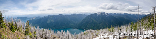
 A few weeks ago we headed back to the Olympic Peninsula to continue our exploration of the Mount Skokomish Wilderness. Last summer, our trek up to the Lake of Angels gave us a taste of the northern reaches of the Wilderness. This year, we decided to check out the southern portion of the wilderness by taking on Mt. Ellinor’s neglected neighbor Mt. Rose. We were hoping for more of the stunning vistas we found on the way to the Lake of Angels, and Mt. Rose did not disappoint.
This is not an easy hike. Like most of the hikes in the Mount Skokomish Wilderness, the grade is steep and offers little respite along the way. However, thanks to a dedicated brigade of trail volunteers, this trail remains relatively clear of blowdowns and other trail damage. The group also continues to re-route the trail in an attempt
 to smooth out some of the steepest sections. Mt. Rose also makes an excellent alternative to Mt. Ellinor, as it receives a fraction of the traffic and offers a nearly identical experience. This hike is perfect for those looking for a challenge with rewarding views, searching for a new conditioning route, or heading to Mt. Ellinor and deciding they want something a little different.
There's a lot more to the Mt. Rose Trail, and you can learn all about it in our book, Hiking Through History Washington. You'll find a trail map, route descriptions, history, and more
 for this and many more hikes throughout the State. Help support hikingwithmybrother.com and the work we do by picking up a copy!
 To get there, take I-5 south to Olympia to Exit 104 toward Aberdeen and Port Angeles. Follow US 101 along Hood Canal just over 35 miles through Shelton to Hoodsport. Turn left onto Lake Cushman Road/State Route 119 and follow for a little over 9 miles to a T-intersection. Head left onto Forest Road 24. Continue for just under 3 miles to the signed driveway of the trailhead parking lot. -Nathan
Print Google Directions >>
2 Comments:
nice
4/23/16 - What an awesome day hike. Views are great! The snow is mostly gone; didn't need spikes and for the patches left it was easy to follow tracks from previous hikers. Trail markers everywhere, so it's easy to stay on track. Not nearly as difficult as the old Mailbox Peak trail, but this one is a bit of a work out. I can see why a beginner or someone out of shape might struggle.
Post a Comment