


Total Ascent: 1800ft
Highest Point: 6433ft
Total Distance: 7.5 miles
Location: N 47° 23.0220, W 121° 1.2900
Required Permit: None
Difficulty: Moderate
 This week we headed over Snoqualmie Pass to continue exploring the Teanaway area. After flipping through some guidebooks and doing a little research online, we set our sights on Jolly Mountain. With clear skies overhead we geared up and headed up the trail toward great views and the remains of a fire lookout.
  There are a number of approaches to Jolly Mountain. The more traditional approach is via the Jolly Mountain Trail #1307, a 12 mile route through pine forest climbing over 4000ft along the way. We decided to take a shortcut to shave off some of that distance and elevation by following logging roads halfway up the mountainside. While shorter, the shortcut is somewhat less scenic, as it involves hiking along forest roads and traversing a few clearcuts. Still, the views from the summit are the real price of this hike, and the shortcut delivers you to those views quickly.
 Unfortunately, we couldn’t determine how the mountain came to be known as Jolly, though we assume there is probably a good story behind it. Between the railroads and the Forest Service, fire spotters were camping on Jolly Mountain’s summit by 1916, though it would be five more years before permanent cabin would be constructed. In 1936, the cabin was replaced and remained standing for over 30 years before it was destroyed in 1968. Today, lingering pieces of rusting metal and some carefully arranged rocks are the only remains of the lookout.
 The shortcut begins by following FR 4315 as far up the mountain as possible. There are two gates along the road, if the first one is locked, you’re better off taking the traditional approach rather than hiking up miles of steep forest road. For us, we were stopped and the second gate, which left only about a mile of road to deal with before connecting up with the Sasse Mountain Trail #1340 and ascending the ridge. The route has a number of ups and downs, so be prepared for something of a workout. And, while hiking through clearcuts isn’t typically something we look forward to doing, in this case they provided a great preview to the vistas that awaiting you at the summit.
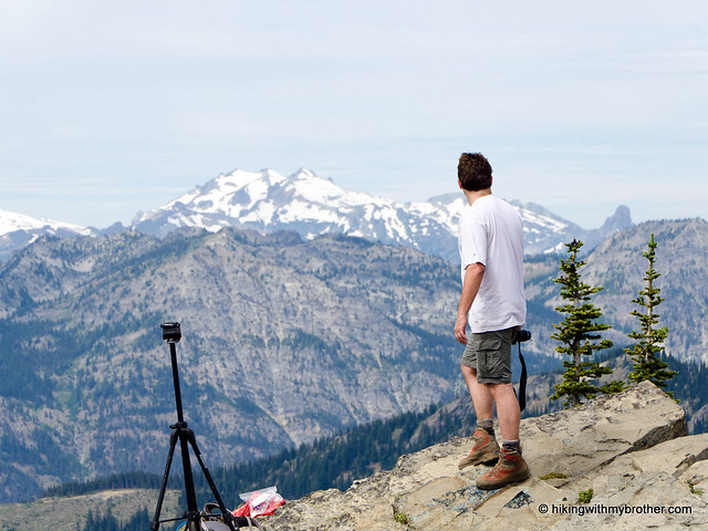
 There are a number of trail junctions along this route which can potentially cause some confusion. To avoid getting turned around, stick to the Sasse Mountain Trail until is connects with Jolly Mountain Trail #1307. Here, head uphill and stay on the Jolly Mountain Trail until you reach the summit and its impressive 360-degree views. You’ll be able to easily pick out Mt. Rainier, Glacier Peak, Mt. Adams, Mt. Stuart and Mt. Daniel. Some of Jolly’s neighbors are also in attendance, including Sasse Mountain and Skookum Peak. Plan on spending some time here soaking up these expansive views.
 While a shortcut, this route is still a little hard on the knees, so we don’t recommend it for everyone. However, the views rank among some of the best we’ve ever seen, making it more than worth the effort to get to the top. Much like Hex Mountain, this is not a wildly popular hike, typically seeing more traffic during the winter months, so you’re unlikely to run into too many other hikers. However, both the Sasse Mountain Trail and the Jolly Mountain Trail are open to both motorcyclists and horseback riding, so be prepared to share the trail.
 To get there, take I-90 to Exit 80. Head left over the freeway following Bullfrog Road to SR 903. Follow 903 15.8 miles through Roslyn and along Cle Elum Lake to FR 4315. The road is not well signed, if you hit the Salmon La Sac Guard Station, you’ve gone too far. Once you find FR 4315, take a right and follow it about six miles as it switchbacks up the mountainside to a locked gate. Park and head up the road to connect with the Sasse Mountain Trail. –Nathan
2 Comments:
Did this hike with my friends on Saturday 9/22/2012. We drove across the pass to escape the Seattle drizzle. Hike was great! Lots of haze from the forest fires but still nice views of the near mountains and great color in the rocks. Will have to go back when the skies are clear. Or maybe go after Hex Mountain. Thanks for posting.
Hey Peiffer,
Glad you guys had a good time! Definitely check out Hex Mountain, that's a great hike as well. :)
Jer
Post a Comment