


Total Ascent: 1600ft
Highest Point: 2800ft
Total Distance: 2.5 miles
Location: N 47° 25.5660, W 121° 39.2340
Required Permit: Discover Pass
Difficulty: Hard
 The Zig Zag Trail is one of many unofficial paths branching off the Iron Horse Trail in search of greater heights and more secluded climbing walls. Around this time of year, when the days get longer but the mountaintops are still snowbound, hikes to rocky bluffs and outlooks at lower elevations have a certain appeal. Built by volunteers, the route offers both views and connections to the Hall Creek Valley and beyond.
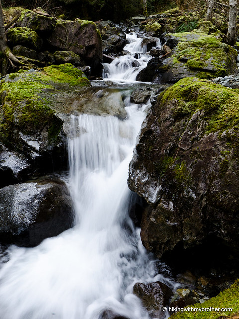
 The Zig Zag Trail climbs up the east side of the Hall Creek Valley. Before you reach the trail, however, you'll pass over or under the restored trestle bridge that spans Hall Creek Valley. Originally built in 1912, the Hall Creek Bridge stood for more than 70 years before a 1988 storm unleashed a torrent of mud and debris downstream, pulling portions of the bridge down with it. For the next 10 years, a 171-foot gap separated the eastern and western portions of Iron Horse State Park. The trails used to by-pass the gap still exist today – the more popular path up Change Creek, and a more hidden route that follows Hall Creek. By 1999, funding was found to repair the bridge and unify the park, which today sees thousands of hikers, bikers, and climbers every year.
A small path signed “Zig Zag Trail” marks the trailhead, a few dozen yards beyond the Hall Creek Bridge. The amount of work trail builders have put into the fledgling path is evident – rocks and logs have been used to stabilize problem areas along the way – but be warned that the trail is still a work in progress. The path is also narrow and can be slick in the rain and melting snow. At about the half-way point, a small overlook signed “Mountain Mutt Rock” is a welcoming place to rest and look down at the Snoqualmie Valley below. Above this point, the trail gets
 rough. Follow the path hacked down long-overgrown logging roads a few hundred feet up to FR 9021, also known as the Hall Creek Road. From here, one can follow forest roads out to Mt. Washington, or make a large loop out to Hall Point and back down to the Iron Horse Trail.
This is a fun little side trip for those looking for more adventure on the Iron Horse Trail. It’s short, but steep, gaining roughly 1600’in a little over two miles -- giving your legs a workout and delivering up some views in short order. It’s not a great trail for large groups or hikers that are looking for a more developed trail. We recommend this for those itching for those summer climbs that are still a few months away who want a taste of what’s to come.
To get there, take Exit 38 off I-90 and take a right. Follow the remnants of old US 10 for about a mile to a widening in the road opposite Change Creek. More than likely other cars will also be parked here. Park and cross the road to find a short path leading up to the Iron Horse Trail. Head left, over the both the Change Creek Bridge and the Hall Creek Bridge. The trail begins a few dozen yards beyond the end of the Hall Creek bridge. – Nathan
Print Google Directions >>
4 Comments:
What do you think of the idea of attempting this in snowshoes? I'd like to get to the top of Greenway, and this looks like the shortest route. Also, could you post this track on a shared folder someplace where I could download it?
Hi! This trail is very steep and narrow, which could make it pretty difficult to navigate with snowshoes. That said, I think the snow level is high enough right now that you could do a lot of this trail snow-free right now. I've posted a link called "Download GPX File" above the map so you can have the track. Enjoy!
Hi. My wife and I hiked this trail last Sunday. The entire trail was snow free. Some portion of the trail is re-routed since you hiked this trail. Now the trailhead is right at the east end of Hall Creek Bridge. My GPS track is at this link. http://alltrails.com/tracks/zig-zag-trail-2-8-2015
Post a Comment