


Total Ascent: 150ft
Highest Point: 1750ft
Total Distance: 4 miles
Location: N 47° 9.1260, W 121° 41.3220
Required Permit: Discover Pass
Difficulty: Easy
 Looking for a change of pace and feeling a little nostalgic for an area we spent a lot of time tromping around in as kids, this week we wanted to visit Highway 410 and the banks of the White River. We’d been keeping an eye out for good low-land hikes for the winter months, and picked out a few options in the area. As the rain started up, we narrowed our choices down and headed out to an old favorite, Federation Forest State Park.
 The General Federation of Women’s Clubs of Washington is the “Federation” that worked to make Federation Forest State Park a reality. The organization traces its beginnings back to 1896, when women's groups from across Washington State came together and formed a statewide branch of the General Federation of Women’s Clubs (GFWC). The GFWC is an organization dedicated to volunteer community involvement that formed in the early 1890s and was recognized by Congress. Today the international organization counts members in every state and in ten countries, and is among the world’s largest and oldest non-partisan, non-religious women’s volunteer service organizations. In 1925, the Washington Federation began raising funds for a park that would preserve forests that were rapidly disappearing in the face of unsustainable logging practices. By 1928 the
  Federation bought a plot of timber land, but due to nearby logging and storm damage, the park was closed in 1939, and the new, current location along the White River was purchased in 1941. Officially dedicated in 1949, the park grew over the next 30 years, acquiring more land and building an interpretive center largely from the generosity of Catherine Montgomery, who willed a substantial sum to the expansion of the park. Today, the park covers 619 acres with miles of hiking trails winding through mossy old growth forest.
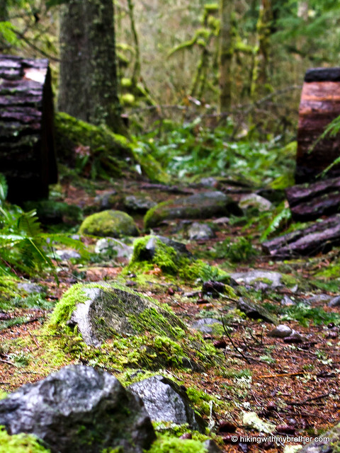
The network of trails is largely composed of a large loop that spans the length of the park. A series of trails bisect the loop, allowing for shorter walks. While most of the trails are on the south side of Highway 410, the loop crosses the highway to explore the less-traveled northern half of the park. Trails dotted with interpretive signs wander over small creeks and through quiet groves. The riverside park is flat, with almost no hills, making it ideal for young families introducing little ones to the forest.
Unfortunately for us, our soggy experience down Federation Forest’s trails was a little more challenging than we were anticipating. We expected a stroll, but recent storms had filled the trail with large ponds of water and transformed paths into streambeds. Large blowdowns were also common, often requiring some careful consideration to figure out how to get around them. While we’re sure the trails will be cleared as springtime comes along, currently most of the trails more than a half-mile beyond the interpretive center need maintenance. This makes the park’s biggest oddity – a large and elaborate “gnome city” in the western portion of the loop, complete with figurines, tiny doors, and miniature vehicles - a little more remote.
 Appearing suddenly and unexpectedly, the “city” makes a fun destination on an otherwise tame hike.
Federation Forest is geared towards families and the goal of experiencing the diverse nature of Washington’s forests with young and old alike. Heavy on picnic tables and fire pits, it is light on interesting hiking. Still, the free interpretive center is open from April to September, making it a nice stop on your way to further adventures down 410.
To get there, take I-5 South to I-405 North, merging onto SR 167 after 2 miles. Follow 167 a little less than 20 miles to Highway 410 East. Follow 410 through Enumclaw for just over 23 miles. Around milepost 41, find well-signed Federation Forest State Park on the right-hand side of the highway. -Nathan
6 Comments:
Thanks for another great post. This trail is closer to us and I'm sure my kids would love this one.Thank you for sharing!
You guys were SO CLOSE to Mud Mountain Dam! You should totally hike the Mud Mountain Rim trail someday :)
elle
We did, we just got the post up today! Saw your review of the hike when researching - nice pics!
I used to hike this when my kids were little and we called it "The Winnie the Pooh Trail" because there was a little mailbox under a tree...)no gnomes at that time) They loved it and it was an easy walk for little kids
Hi Kathy, Thanks for sharing the story. We've got many memories from when our Mom use to take us out hiking as kids that we still talk about when we're on the trail today. :)
Don't remember ever having been to this park before. So incredibly lush and green. A bit soggy toward the far end of the park so we (Sasha and I) cut off a bit early and just explored more back nearer the parking area. My Discovery pass expired today so I will be getting another annual one this week. Best investment ever. Thanks guys.
Post a Comment