


Total Ascent: 2400ft
Highest Point: 2850ft
Total Distance: 10 miles
Location: N 47° 51.9720, W 121° 35.9820
Required Permit: None
Difficulty: Hard
 During the winter months we always have a backup hike, just in case something goes awry on the way to the trailhead. This past week was another shining example of the need to fall back on “Plan B.” Our cursory research regarding a hike to Mineral City missed a key fact: the Index-Galena Road to the trailhead had been washed out. So we headed back to Gold Bar to explore a hike we knew very little about: the trail to Isabel Lake. We found the trailhead after some fumbling attempts, hit the trail and quickly discovered that we would very likely be alone for the duration of the hike.
 There’s not a lot out there on Isabel Lake, and we would now assume hikers simply avoid it. During our research, we learned that the area is beloved by many other outdoor-enthusiast types – mostly lovers of all-terrain vehicles and motorcycles. Evidence of their presence was legion. A goodly portion of the hike is along utility roads winding under power lines and by wrecked cars, while dodging mud holes and piles of garbage. Overhead you may hear the occasional float plane coming in to land on Isabel Lake, evidently an ideal recreational destination for pilots flying out of Seattle.
In addition to the trail being somewhat unpleasant, the path to the top is occasionally difficult to follow. Paths are constantly branching off from the main road and the road itself occasionally splits off in multiple directions. To make matters worse, bridges over May Creek are universally
 washed out, forcing a hiker to search up and down the riverside for a fallen log or some rocks to hop across. This is definitely a hike to bring the GPS on so that you can avoid getting turned around or lost.
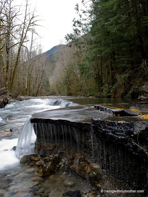
As you continue to ascend, the road becomes progressively rougher and the crossings more treacherous. Perhaps during summer and early fall the water levels fall to a more approachable depth. When we crossed, the rocks were covered in layers of ice; pretty, but it made crossing particularly difficult. Perseverance across May Creek and up a particularly nasty washout will lead you to a marked trail into the forest. Here, the hike becomes enjoyable. More a bootpath than a full-fledged trail, the way is occasionally marked by pink ribbon, and it is clear that one needs to follow the creek in order to get to the lake.
We heard Isabel Falls before we saw it. We weren’t expecting a pretty amazing 200’ waterfall at the end of the hike – and this made up for some of the drudgery we’d endured to get there. The falls have a feeling of isolation and seclusion. Clambering up the rocks above the first tier of the waterfall is well worth the effort, and is the perfect place to settle down for lunch. We happily spent a good deal of time here just taking the waterfall in.
 When you’re done basking, Isabel Lake is just a few hundred feet above – find and follow the trail on the right side of the falls to reach the shore.
This is a hard hike to recommend. While the goal is noble, most of the journey is unpleasant. However, we do note that with the area currently closed to motorized vehicles, this might be the best time to explore Isabel Lake. We can’t say this is a hike for just anyone – it’s a slog, and one should definitely have a good deal of experience hiking and navigating via map or GPS before attempting it.
To get there, take Highway 2 through Gold Bar. About two miles past town take a left on Reiter Road. Follow Reiter Road for another two miles, avoiding the turn down May Creek Road. There should a large graveled area on the left after two miles. Find a place to park and unload. Follow the access road toward the powerlines and onward to Isabel Lake. -Nathan
2 Comments:
Awesome hike and well worth the calories burned! There is also an old mine shaft halfway up the trail between the bottom of the falls and the lake. Fishing was good; caught a few brookies and a cut. Working on some shortcuts to eliminate a few miles.
Boondog -
If you can, keep us in the loop on your trail work; we love a shortcut!
We found out after we missed the mine. Next time. Glad it was a good trip.
Post a Comment