about us | links | permit info
Subscribe to Hiking With My Brother Email Subscribe Follow Hiking With My Brother on Facebook Follow Hiking With My Brother on Twitter Hiking With My Brother Picasa Hiking With My Brother YouTube

Cape Flattery Trail

Our Hiking Time: 1h
Total Ascent: 300ft out
Highest Point: 350ft
Total Distance: 1.4 miles
Location: N 48° 23.1533 W 124° 43.5966
Required Permit: Makah Recreation Pass (details below)
Difficulty: Easy

Nathan's PhotoA few weeks ago we took a weekend to head out to the Olympic Peninsula to explore a few hikes along the Pacific Coast. One of those hikes was Cape Flattery, a short trek out to dramatic seascapes and the chance to catch glimpses of marine life. What this hike lacks in distance it more than makes up for in views of waves crashing against a fairytale coastline.

Cape Flattery’s rocky cliffs not only overlook Tatoosh Island, but they have the distinction of being the most northwesterly point in the continental United States. Nearby Cape Alava only narrowly beats out Cape Flattery for the western most point by a little over 350 feet. Other than the Pacific Ocean, Cape Flattery is the oldest place name on the Washington Map still in use today. The cape was sighted by Captain James Cook on March 22, 1778, when it “flattered” the crew with hopes of a harbor or the entrance to the Strait of Juan de Fuca. Bad weather hid the “pretended” Strait of Juan de Fuca from Cook, but his name for the jut of land won out over the native name of “Klasset” and other early explorer’s attempts at a name, such as Claaset and Classet.

Tatoosh Island sits about a half-mile off Cape Flattery, and was named after a Makah chief by Captain John Meares in 1788. Meares met the chief on the island and observed the Makah hunting whales and drying salmon, using the island as a base. By the 1850s, there was an increasing need for a lighthouse near Cape Flattery. One was constructed and first lit on December 27, 1857. Over the years a number of facilities grew up on the 20-acre island including weather and radio stations. Throughout that time keepers manned the lighthouse until 1977 when it was automated. Today, the lighthouse is decommissioned and a solar powered light tower helps guides ships into the Strait. The Makah Tribe now control the island, with only a small fenced graveyard to serve as a reminder of the many people that once lived on the island.

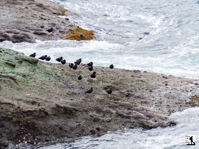
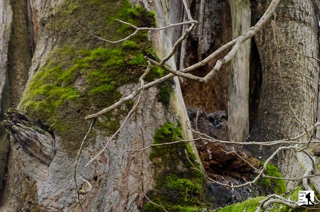
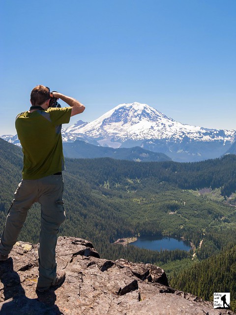
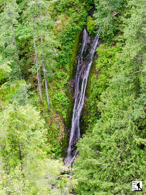
From the parking lot, the wide graveled trail descends into mossy cedar forest. Before long reach the first of a series of boardwalks and wooden steps meant to help you avoid the mud that frequently lines the trail. As you near your destination a couple of paths lead off the main boardwalk out to observation platforms that give a front row seat to expanses of ocean filled with tree-topped fingers of rock, exposed cliffs riddled with caves and the sound of waves crashing against the cape. Continue onward to find a large observation deck built at the very tip of the cape that provides commanding views of Tatoosh Island, Vancouver Island and the ocean carved coastline. If you’re lucky, you may be able to pick out some whales in the distance, or find otters or seals lounging on the rocks below.

This little hike is the perfect addition to a trip out to the Pacific site of the Olympic Peninsula. The trail is well maintained and it should be approachable for almost any hiker, though roots and uneven terrain may trip up little feet. With little elevation gain, short milage and an impressive seascape, this is a great hike for those who are a little reluctant to get on the trail. Once you’ve soaked up the views, round out your hiking day by taking a trip down to Shi Shi Beach and exploring the Point of Arches. Keep in mind that the area is managed by the Makah Tribe and all visitors are required to purchase a parking permit from the tribe - Washburn’s in Neah Bay is a good place to get one.

To get to there, take the Bainbridge Island ferry to Bainbridge Island. From the terminal, follow SR 305 for 13 miles to SR 3 North. Follow SR 3 to the Hood Canal Bridge, taking a left over the bridge onto State Route 104. Follow SR 104 as it merges onto US 101 and continue 35 miles to Port Angeles taking a left on Lincoln Street. Continue for about 5 miles to the junction with SR 112. Veer right and continue on SR 112 for about 65 mile to Neah Bay where it becomes Bayview Avenue. Continue another mile through town to Fort Street. Take a left and follow for two block to 3rd Avenue. Take a right and in one block take a left onto Cape Flattery Road. Continue of Cape Flattery Road for 7.5 miles to the trailhead. -Nathan

Print Google Directions >>

Cape Flattery

Nisqually National Wildlife Refuge

Our Hiking Time: 2h 15m
Total Ascent: 0ft
Highest Point: Sea Level
Total Distance: 4.0 miles
Location: N 47° 4.3433, W 122° 42.8216
Required Permit: Day Pass or National Park Pass
Difficulty: Easy

Nathan's Photo
A few weeks ago we found some time to head down to Nisqually National Wildlife Refuge to do a little winter wandering. While more of a walk than a hike, there are miles of trails to explore in the Refuge and we hoped for enough nice weather to catch a glimpse of some wildlife. While the weather didn’t hold, we did find more than enough to fill an afternoon of off-season hiking.

Long before it was a refuge, wildlife flocked to the Nisqually Basin and, as a result, the Nisqually Tribe were able to live off the land for generations. Then, in 1833, the Hudson Bay Company established a trading post in the Basin, which brought more Europeans to the area. By 1854 the first Indian treaty in Washington Territory was signed in the Nisqually Basin, in a grove of trees along McAllister Creek known as the “Treaty Trees.” Today, members of the Nisqually Tribe still fish for salmon under the terms of that treaty.

Over the years, homesteaders made various attempts to drain marshes and estuaries and build small dams to hold back the tide. Traces of these early efforts can still be seen in the Basin’s mudflats. Then, in 1904, a lawyer-turned-farmer named Alson Brown bought up 2,350 acres of the Basin and began working to transform large sections of the Basin. It was Brown that built the large dike to keep back the sea - portions of that dike are still a prominent feature of the Refuge. Brown also used the latest in farming techniques and equipment to create a self-sufficient farm, which became a model for farms seeking to produce more than a single product. With the advent of World War I, Brown's fortunes took a turn for the worse, and he lost the farm to creditors. After changing hands a number of times, the land was eventually sold to the federal government and in 1974 the Nisqually National Wildlife Refuge was established to protect migratory birds and this sensitive habitat.

From the parking area, the Twin Barns Loop Trail branches off in one of two directions each path eventually leading out to a pair of barns left over from the area’s farming past. Stroll along boardwalks and wide graveled paths out to a number of observation platforms overlooking marshy ponds and wetlands. The Twin Barns Loop links up with the Nisqually Estuary Trail which cuts across the Refuge and leads to a mile-long boardwalk that stretches out toward the Sound. Depending on the time of year and the tide, you can find yourself walking above a large expanse of water or muddy tidal flats -- both of which are likely to be full of any number of birds or other wildlife. Complete with viewing platforms, observation towers and wildlife viewing blinds, the Boardwalk Trail is well worth a visit.


The Nisqually National Wildlife Refuge is accessible in every season, though the very end of the Boardwalk trail is closed for a few months of the year during the winter. With trails that are almost entirely flat, this hike is easily accessible for just about everyone, while boardwalks and paved sections of trail allow for strollers or wheelchair access. At the same time, in order to protect the wildlife, no dogs are allowed in the Refuge and no jogging or biking are prohibited. Whether you’re an avid birdwatcher or just looking to get outside, the Refuge is well worth a visit.

To get there, take I-5 south to Exit 114. Take a right onto Brown Farm Road, following it under the freeway to a T-intersection. Take a right and find parking and the visitor's center in a little less than a mile. The Refuge does charge a small daily entrance fee, though a number of passes are honored. -Nathan

Print Google Directions >>

Nisqually Wildlife Refuge

Summit Lake Loop Trail #1177

Our Hiking Time: 2h 45m
Total Ascent: 1300ft
Highest Point: 5800ft
Total Distance: 6.1 miles
Location: N 47° 2.3333 W 121° 50.1539
Required Permit: Northwest Forest Pass
Difficulty: Moderate

Nathan's PhotoAt the end of last summer we headed out toward the Carbon River entrance to Mt. Rainier National Park to do a little exploring in that area. One of the hikes we chose was Summit Lake, which is also one of the most popular. With big views of Mt. Rainier and a sizable alpine lake, it was easy to see why.

Summit Lake is a glacially carved alpine lake situated at the upper end of the Cayada Creek Valley just inside the Clearwater Wilderness. The Wilderness was established in 1984 and now protects over 14,000 acres of old growth forest and wildlife. Records are a bit sketchy, but it seems likely that the Summit Lake Trail was first blazed by the Forest Service when building the fire lookout that was once perched on nearby Bearhead Mountain. Summit Lake serves as a excellent water source in the summer months, and the lookouts stationed on Bearhead Mountain would have been drawn to the picturesque setting of the lakeshore. Today, visitors flock to the Summit Lake to take in that same alluring mixture of meadow, snowcapped mountain and alpine lake.

From the trailhead, the Summit Lake Trail #1177 begins by climbing up through a young forest still recovering from a recent harvest. Soon find yourself entering more mature stands of fir and hemlock as the trail swings into a long switchback up the mountainside. The trail here is fairly wide and well maintained, though there are plenty of roots to trip you up if you’re not paying attention. After about a mile of trail reach a junction with the Carbon River Trail #1179 and Twin Lake. A short unmarked trail leads out to lonely Twin Lake, which lacks both a twin and the impressive landscape waiting at Summit Lake.

Push on from the junction to one of the steeper sections of the hike, following the trial as it quickly ascends the ridgeline. The grade soon becomes more reasonable, giving you time to enjoy the wildflowers that often line the trail, as well as occasional pocket views of Lake Lily hiding on the other side of the ridge. Roughly 2.5 miles from the trailhead emerge from the woods into the grassy meadows surrounding Summit Lake. Ahead of you the rocky prominence of Summit Lake Peak rises directly behind the lake and as you reach the lakeshore, Mt. Rainier looms large to the south. Settle in to enjoy the lake or press onward for bigger views.

If you’re up for more, the trail splits into a loop, winding around the lake and up to the top of Summit Lake Peak. Either way you go, there is often wildlife found in the meadows, including bear, deer, marmot and elk. The trail to the top is more challenging than the trail to the lake; it’s rough, steep and narrow, but the rewards are worth the extra effort. From the top, the deep blue of Summit Lake competes with the white flanks of Mt. Rainier. The closest neighbors are Bearhead Mountain to the west and Pitcher Mountain to the east, with Coplay Lake filling a bowl just to the right of Bearhead. Beyond that, an ocean of mountaintops spreads out in every direction, with far too many peaks to name. When you’ve had your fill, continue down the trail and complete the loop.

This is a fairly popular trail in the summer months, and it's easy to see why. The wildflower-filled meadows around Summit Lake are sure to please any fan of an alpine lake, and the big views from the top of Summit Lake Peak are more than enough to satisfy a devoted peakbagger. While it does have some elevation, most hikers will find this trail fairly accessible. And, with campsites available around the lake and more to explore along the Carbon River Trail #1179 and the Bearhead Mountain Trail #1179.1, this hike also makes for a decent backpacking destination.

To get there, take I-5 South to I-405. From I-405 take SR 167 south toward Auburn. In 20 miles take the SR 410 Exit toward Sumner/Yakima. Follow SR 410 for 12 miles to SR 165. Take a right and continue on SR 165 for about 10 miles through Wilkeson and Carbonado to the Carbon River Road/Mowich Lake Road junction. Veer left onto the Carbon River Road and follow for 7.5 miles to FR 7810, just before the Carbon River Ranger Station. Turn left onto the FR 7810 and continue 6.5 unpaved miles to the trailhead at the end of the road. –Nathan


Print Google Directions >>

Summit Lake

Falls View Canyon Trail #868

Our Hiking Time: 1h 10m
Total Ascent: 300ft
Highest Point: 400ft
Total Distance: 1.8 miles
Location: N 47° 47.3633, W 122° 55.7516
Required Permit: None
Difficulty: Easy

Nathan's PhotoThe Olympic Peninsula offers everything from sandy beaches to windswept peaks and there are all manner of hiking trails to access those destinations. Some of those trails are difficult to reach, while others can be found just off the highway. This hike is in the latter category. The trails at Falls View offer a rhododendron-lined tour of a river canyon and a front row seat to a waterfall tumbling down 200ft into the Big Quilcene River. As an added bonus, these short and easily accessible trails can be explored any time of year.

Falls View Campground is situated on a bluff above the Big Quilcene River and likely owes its existence to its namesake waterfall. We weren’t able to dig up much in the way of the history behind the building of this campground, although we did find that the area is sometimes referred to as Fallsview in older guides and reference books. For the record, US Board of Geographic Names lists the official name of the campground as “Falls View.” While the falls themselves have been christened Falls View Falls or sometimes Campground Falls, the stream that creates the cascade has gone unnamed.

This hike is actually two separate trails, the Falls View Loop Trail #848 and the Falls View Canyon Trail #868. Both trails begin from the campground. The Falls View Loop trail clocks in at about a tenth of a mile, and leads out to a viewpoint overlooking Falls View Falls before looping back to the parking area. Take a few minutes to wander down this trail to get an idea of the canyon you will soon be descending into. Once you return to the trailhead, head toward the Falls View Canyon Trail, which quickly switchbacks down to the riverside to a view of the base of the falls.

From the canyon floor the trail wanders through a young forest of fir and alder rising out of a thick underlayer of fern and salal. The roar of the river is never far as you progress along the narrow trail, which splits after about three-quarters of a mile.  Head right and continue onward to the far reaches of the trail to find a calm section of the Big Quilcene River.  Here the water pools at the end of a series of rapids, and the shore provides plenty of room to stretch out and enjoy the river. Once you’re done exploring the rocks, return to the trail and follow it as it loops back toward the campground. This section of trail  is a little further away from the river, and it passes quickly. Before you know it you’ll reconnect with the trail and the river and find yourself climbing up the canyon wall to the trailhead.

While this pleasant river walk isn’t the most spectacular trail in the Olympic National Park, it does manage to pack both panoramic views of a big waterfall and access to a rushing river filled with moss-covered boulders into less than 2 miles of trail. This makes it a great addition to a day of short hikes or a nice way to stretch your legs while traveling on to your final destination. There is a bit of a climb into and out of the canyon, but hikers of all ages should be able to tackle these trails without a lot of difficulty. Falls View Falls is somewhat seasonal, and is best viewed in the winter and spring when waters are at their highest. In warmer years, the falls can dry up completely. If you’re going in the winter, the campground may be closed - simply park outside the gates and hike the short distance to the trailhead.

To get there, take I-5 south through Tacoma to Exit 132B SR 16 toward Bremerton. Continue on SR 16 for 27 miles to merge with SR 3 North. Follow SR 3 to the Hood Canal Bridge, taking a left over the bridge onto State Route 104. Follow SR 104 as it merges onto US 101 and continue 13.4 miles to Falls View Campground. Turn right and find the trailhead in the day use area of the campground. -Nathan

Print Google Directions >>

Falls View Falls
Copyright 2008-2016 - hikingwithmybrother.com
hikingwithmybrother@gmail.com