


Total Ascent: 3800ft
Highest Point: 6547ft
Total Distance: 7 miles
Location: N 47° 25.9020, W 121° 18.0360
Required Permit: Northwest Forest Pass
Difficulty: Hard
 Not long ago, we had the chance to return to the Rachel Lake and Box Canyon aiming to climb Hibox, a prominence along Box Ridge’s rocky spine. We really enjoyed our hike up Alta Mountain a few years ago, and hoped Hibox would be a similar experience. As it turned out, Hibox Mountain is a little more challenging than Alta Mountain, but the views are at least as good, if not better.
Back before Washington was a state, it was part of the Oregon Territory, and settlers carved out their
 lands on either side of the Washington Cascades. By 1853, Washington’s population had grown to the point that it was re-organized as a separate government known as the Washington Territory. Almost immediately, the new government began to tackle the need to connect the eastern and western portions of the territory. Surveyors and explorers set about finding suitable passage through the Cascades, eventually finding many routes, including Snoqualmie Pass. Box Canyon was explored during this time, and was named for the way Rampart Ridge and Keechlus Ridge “box” you in as you try and cross the Cascades. Hibox (sometimes called High Box) is the highpoint on Box Ridge, and was named by forest officers.
 The hike beings at the Rachel Lake Trailhead #1313, following Box Canyon Creek through small stands of pine and lush slide zones filled with bracken fern and salmonberry. The trail here is relatively flat, with only small ups and downs and an occasional log to hop over. The creek also provides a couple of open areas that make for great rest stops on your return trip. Keep an eye out for
 the rocky finger of Hibox on the ridge. Your first glimpse will be in a large slide area and again at a second clearing at a little over 2 miles. Just after you cross the second clearing, look in the trees for an unmarked but obvious trail heading toward the mountain.
 From here, there is only one direction: up. Switchback up the shoulders of the ridge, following a rough and narrow trail through the trees toward the summit block. Eventually, the trees recede, replaced by talus and scree veering to the right, under the cliffs that make up the mountaintop. Some sections of the trail are loose rock here, so tread carefully as you climb up to the ridgeline.
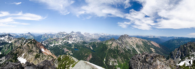
Your last challenge is the short scramble to the top where 360-degree views await. From those heights you can easily pick out nearby Alta Mountain, Three Queens and the Park Lakes to the north. Beyond you can see Chikamin Peak, Lemah Mountain, Chimney Rock and Summit Chief Mountain. On a good day you’ll be able to pick out Glacier Peak. As you turn east you’ll see Mt. Hinman, Mt. Daniel and Mt. Stuart. To the south is Rampart Ridge and Mt. Rainier. Keep turning west to pick out Mt. Thompson out from among the Snoqualmie Peaks. Settle in to see how many more peaks you can count.
 Climbing up to Hibox will be a challenge for some hikers and we don’t recommend it for everyone. Once you leave the Rachel Lake Trail, the trail is steep, rough, and is easy to lose in the talus fields. On the upside, you can also expect to leave most hikers to Rachel Lake and Alta Mountain, as the route does not get a lot of traffic. This hike can be great alternative, as long as you’re comfortable with a little route finding and a small amount of scrambling. If you’ve already explored Rampart Ridge and are hungry for a little more, Hibox might be the perfect fit.
 To get there, take I-90 to Exit 62. Turn north and drive five miles to the Lake Kachess campground, then turn left onto Box Canyon Road #4930. Continue for four miles to the large trailhead parking area. –Nathan
Print Google Directions >>
1 Comments:
Thanks for this. Could you please post the GPX track? -Dave
Post a Comment