about us | links | permit info
Subscribe to Hiking With My Brother Email Subscribe Follow Hiking With My Brother on Facebook Follow Hiking With My Brother on Twitter Hiking With My Brother Picasa Hiking With My Brother YouTube

Mt. Kent via McClellan Butte Trail #1015

Our Hiking Time: 5h 30m
Total Ascent: 2800ft
Highest Point: 5087ft
Total Distance: 7 miles
Location: N 47° 23' 23.4240, W 121° 37.0620
Required Permit: None
Difficulty: Hard

Nathan's PhotoWe were going over our maps looking for potential hikes when we turned up a route to the top of the Mt. Kent. Digging deeper, we found that very few hikers had made the trek to Mt. Kent’s often-overlooked summit. Sensing a challenge, we picked out our route and set out for the trail the following weekend.

Living in the shadow of McClellan Butte, Mt. Kent has never drawn a crowd. The first recorded ascent was April 10, 1938 by a group of Mountaineers, probably looking for something a little different after duke duchess of kent hikingwithmybrotherclimbing McClellan Butte dozens of times. Unfortunately, little else is written about this lonely peak. We’d welcome any local lore anyone has to share.

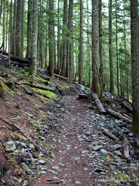
A little over half the route to Mt. Kent follows the McClellan Butte Trail #1015. This section is easy to follow and, while a bit challenging, does not pose any real difficulty. However, once you leave the McClellan Trail, route-finding and bushwhacking are the name of the game.

The fun begins just as the McClellan Trail plateaus and starts to lead you around the back of the mountain. Your first glimpses of Chester Morse Lake signal your imminent departure from maintained trails. A short push through the trees leads to a large talus field. Follow the ridgeline connecting McClellan Butte and Mt. Kent. Below you may see a forest road; however, this road is located within the Cedar River Watershed and is closed to public access.

mtkent hikingwithmybrotherClimb down the talus field and stay on the east side of a large ridge as you head toward Alice Lakes. From the Alice Lakes basin, find the path of least resistance up through talus fields, patches of mountain blueberry, and the occasional hemlock sapling. Climbing out of the cirque encompassing Alice Lakes is tough. A few sections are steep enough to properly be called a scramble – you’ll probably be forced to use your hands a few times on the way up.

Emerging from the trees to the summit reveals a decent view of McClellan Butte and the Duke and Duchess flanking the Alice Creek Basin. On a good day, Mt. Rainier will rise proudly over Chester Morse Lake . . . of course, we didn’t get to see any of that. Low clouds heavy with rain made it impossible to see anything at all. So we settled down for a soggy lunch and signed the summit register.

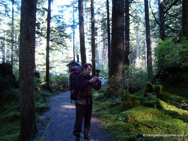
Despite the rain, this was an enjoyable hike that we’d recommend to those that like a challenge. Be prepared to do some stomping through vegetation and to use your route-finding skills. Because footpaths are faint at best, often disappearing into themt kent alice lakes hikingwithmybrother underbrush, a GPS will make this hike more manageable. Alice Lakes feel secluded and remote, and we never encountered another soul once we left the McClellan Trail. All in all, a nice little escape.

A number of sources warn of the high avalanche risks on both McClellan Butte and Mt. Kent. The talus slope above Alice Lakes is extremely steep and avalanche prone. Use caution when hiking these areas.

To get there, take I-90 to Exit 38, then take a right and head past Olallie State Park and the access to Deception Crags for about two miles to reach FR 9020. Follow the progressively rougher logging road to the roadblock at 4.5 miles. -Nathan

Print Google Directions >>

Mt. Kent

Anniversary Post: Celebrating Two Years

Nathan's PhotoIt’s hard to believe it was just two years ago that hikingwithmybrother.com was launched. What began as two brothers tracking their hikes has slowly morphed into something of an online hiking guide for local hikers. We’re happy that so many hikers have been able to use the information they find on hikingwithmybrother.com to plan their trips.

We’ve been a lot of places over the last 12 months. We’ve tromped through a great deal the Middle Fork Snoqualmie River Valley. We broke out of the I-90 corridor and explored the North Fork Snoqualmie River and several hikes on Highway 2. We’ve been to the top of lofty peaks, at the shores of alpine lakes, and have slogged down trails more stream than earth and done far more than our fair share of bushwhacking--all to bring you back the most up-to-date route descriptions and trail conditions.

Although this second year found us on trails that led to more adventure and more secluded destinations, it was really defined by a single overarching theme: rain. Much more than our first year, the rainy season began early and stayed late. Snow lingered until late June, and it seemed that almost every hike forced us to break out the rain gear. It was a tough year for hiking.

Beyond the rain and the adventure, perhaps our most exciting development this year was the launch of the hikingwithmybrother app. If you haven’t downloaded this yet, take a minute to check it out – the scaled down version of the blog lets you find a nearby hike with a tap of a screen. It’s a great resource when hiking plans need to change at the last minute.

We’re looking forward to our next year, and we’ve got some great hikes planned. You’ll see us up in the Mountain Loop Highway, spending trail miles on Highway 2, and exploring remote sections of the popular Mt. Si Natural Resource Conservation Area and the West Tiger Mountain Natural Resource Conservation Area. We also have some big trips planned, like a summit of Mt. Adams and a multi-night tour of the Enchantments.

We hope you’ve enjoyed our first two years. We hope you’ll stick with us for the many good hikes to come. Thanks for your support, and we’ll see you on the trail.

-Nathan & Jer

Goldmyer Hot Springs via Middle Fork Trail #1003

Our Hiking Time: 10h
Total Ascent: 2000ft (1000ft out)
Highest Point: 2100ft
Total Distance: 22 miles
Location: N 47° 28.9320, W 121° 23.0520
Required Permit: Northwest Forest Pass
Difficulty: Moderate

Nathan's PhotoWe’ve spent a lot of time in the Middle Fork Snoqualmie Valley the past few years. We’ve climbed mountains, followed creeks to spectacular waterfalls, and explored hidden lakes. But, despite hearing a lot about it, we had not yet made it out to one of the valley’s signature destinations: Goldmyer Hot Springs. As autumn continues to bring cooler temperatures, we set out on a short overnight to see the springs before winter set in.

goldmyer hot springs hikingwithmybrotherGoldmyer Hot Springs is named for William Goldmyer, who purchased the land around the hot springs and built a lodge for local lumberjacks and miners around 1900. The lodge eventually became something of a resort, and the hot springs were expanded. Back around the turn of the 20th century, mineral springs were big business as people sought them out for their restorative properties. The resort operated for many years, supported by a railroad that made access much easier than it is today, as well as emerging hydroelectric technology that powered the encampment. Eventually the resort closed, the land changed hands, and the hot springs went into decline until the ‘80s when a nonprofit group bought the land and began a program of resident caretakers that continues to this day.

Currently, because of a road closure, access to Goldmyer is a 10 mile riverside stroll following the Middle Fork Trail #1003. This trail is extremely well maintained. The effort that trail volunteers put into it is readily apparent in the extensive network of bridges and boardwalks. Although goldmyer hot springs hikingwithmybrotherthere are a few ups and downs, for the most part the trail generally follows the remnants of old logging roads and is fairly gentle. Wander under alders, hemlocks, and big leaf maples, and take advantage of breaks in the canopy to see Mt. Garfield, the granite cliffs of Stegosaurus Butte, and Mt. Thompson. Cross roaring creeks, tumbling cascades, and the occasional wash-out before reaching Goldmyer and a well-earned soak.

There are two approaches to the hot springs. Both follow the Middle Fork Trail for 6 miles to the Dingford Creek Bridge. At this point, you can continue on the Middle Fork Trail for another 4 miles to Burntboot Creek and a log crossing to the Goldmyer property. Alternatively, you can cross the bridge and follow the Dingford Creek Road 4 miles to Goldmyer. The forest road is not as enjoyable as the trail, but a couple unbridged creeks can be difficult to cross when waters run high during the spring thaw or heavy rains.

The hot springs themselves are fairly small. Probably no more than 10 people can fit in the various pools at any one time. Perhaps for this reason, Goldmyer limits camping to 20 people a day and groups to no more than 12. Although a reservation is not strictly necessary, it will guarantee you a campsite during the busy summer season. Check out goldmyer.org for more details.

This is a great hike for beginning backpackers. The ease of the trail goldmyer hot springs hikingwithmybrotherand the comfortable destination (the tent sites are well groomed, the nearby river makes for easy access to water, and an enclosed outhouse borders on luxury) make it easy to convince the skeptics that backpacking is a lot of fun. Moreover, the Middle Fork Trail is really a pleasant journey that takes you though some of the best portions of the valley. The Middle Fork Trail route also allows for some interesting side trips for those looking for a little extra. At the 5-mile mark, you reach Cripple Creek and a mile-long scramble up to Tin Cup Joe Falls. At just over 8 miles, the trail intersects with the Rock Creek Trail #1013.1, which leads out to Snow Lake and Snoqualmie Pass.

To get there, take Exit 34 off I-90 and take a left on 468th Ave. Follow the road past the truck stop for about a half-mile until you reach SE Middle Fork Road, also known as Forest Road 56. Continue to follow the twists in the road until the pavement runs out. Continue on FR 56 for 11 miles, to the Middle Fork Trailhead parking lot. The trailhead and Gateway Bridge are at the north end of the lot. - Nathan

Print Google Directions >>

Goldmyer Hot Springs

Denny Mountain Trail - Alpental Ski Resort

Our Hiking Time: 6h 30m
Total Ascent: 2500ft
Highest Point: 5608ft
Total Distance: 4.5 miles
Location: N 47° 26.3400, W 121° 26.6400
Required Permit: Northwest Forest Pass
Difficulty: Hard

Nathan's PhotoAt some point, after doing a number of hikes nearby, we decided that we’d looked at Denny Mountain’s mile-long ridgeline enough times to warrant an excursion to the top. Despite some cloudy weather, we headed out to Alpental to tackle the steep slopes and check out the summit before the ski season set in and closed the mountain to hiking.

denny mountain hikingwithmybrotherThere is some argument over which member of early Seattle’s Denny family the mountain was named after. Most assume everything “Denny” is named after Arthur Denny, though his brother David spent considerable time in Snoqualmie Pass staking mining claims. Whichever Denny it was, since 1968 most people know the mountain slopes as the Alpental Ski Area. Famous for very steep and very challenging runs, Alpental was a destination for wintertime thrill-seekers from the moment it opened.

Unsurprisingly, Denny Mountain is much less famous for hiking. Equally unsurprising, there is no real trail to the top of Denny Mountain. Occasionally a trail will be hacked through a particularly dense patch of huckleberry, but mostly the uphill trudge is an exercise in finding the path of least resistance. Ski slopes are less friendly when the snows disappear. Rocks and shrubs cover the mountainside, and resorts tend to leave things wherever they happen to fall, knowing that snows will obscure old boards, pieces of concrete and derelict construction equipment. The evidence of decades of skiing make most of the lower mountain less pleasant to hike through.

denny mountain hikingwithmybrotherWe followed the Armstrong Express chairlift up through the clouds to the base of the upper mountain. Although mostly successful with route finding, we still found ourselves neck-deep in bramble or backsliding on a loose patch of scree. While challenging, the first half of the hike is manageable without too much trouble. The upper mountain is an entirely different story. Be prepared for an all out bushwhack up gullies and small cliffs. Small hemlocks and huckleberries served as much needed handholds as we slowly worked our way up the mountainside. Thankfully, a few short plateaus give some relief from the slog.

Attaining the true summit can be slightly tricky, as it requires wiggling through narrow opening between the rocks. Once through enjoy the views of Snoqualmie Mountain and Guye Peak. And, if you’re lucky enough to make the climb on a less cloudy day, your 5,522’ perch should provide some excellent views of the Snoqualmie Valley and Mt. Rainier. Ignore the weather instrumentation and savor the rewards of a difficult hike.

This hike is probably better done in snowshoes, as the snow will smooth out most of the rougher aspects of the hike. If, like us, you enjoy the adventure and extra challenge, Denny Mountain certainly has more denny mountain hikingwithmybrotherthan enough of both to satisfy most hikers. Aside from those gluttons of punishment however, Denny Mountain is a difficult hike to recommend to anyone else. Somewhere on the slopes of the upper mountain the amount of effort the hike demands surpasses the reward. If you’re looking for a rigorous hike and some views, Snoqualmie Mountain is a much better choice.

To get there, take I-90 to exit 52. From the exit, take a left onto Alpental Road for about two miles to a large gravel parking lot. The unmarked trailhead is across the road to the left. -Nathan

Denny Mountain
Copyright 2008-2016 - hikingwithmybrother.com
hikingwithmybrother@gmail.com